CIRRUS Flight Operations Location at Anoka County Airport (KANE), Blaine, Minnesota
You are here: CIRRUS Flight Operations Home | Location
Click on the map below to visit http://maps.google.com/maps
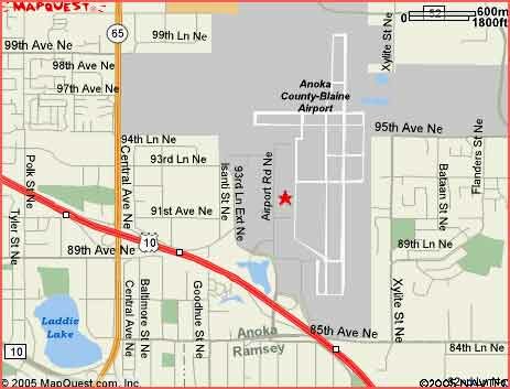 |
Anoka County Airport (KANE), Blaine, Minnesota
CIRRUS Flight Operations is located south of the control tower on the west side of the Anoka County Airport (KANE).
Driving & Flying Directions
CIRRUS Flight Operations is easy to access from all directions off interstate 35W. From the north or south, travelers can take Hwy 10 exit to Airport Road and follow the signs to the airport. Once in the airport, look for the Cirrus sign just south of the control tower.
Highway I-35W to Highway 10 West:
Exit on Airport Road. At the top of the exit ramp turn right. Take the next right through the gate. When you get to the T intersection go left at the stop sign. Go north to the Cirrus sign and turn right into the parking lot.
From Western Suburbs:
252 to 610 to Highway 10 East. Exit Airport Road. Left at the top of the exit ramp, over the bridge. Turn right through the gate. When you get to the T intersection go left at the stop sign. Go north to the Cirrus sign and turn right into the parking lot.
Flying:
10 miles N of MINNEAPOLIS , MN
45-08-42.000N , 093-12-41.000W
162522 (seconds), -335561 (seconds)
Anoka County Airport (KANE) Information
- CTAF: 132.4
- UNICOM: 122.95
- ATIS: 120.625
- WX AWOS-3: PHONE 763-780-9025
- ANOKA GROUND: 121.85 [0700-2100 OCT-APR; 0700-2200 MAY-SEP]
- ANOKA TOWER: 132.4 [0700-2100 OCT-APR; 0700-2200 MAY-SEP]
- MINNEAPOLIS APPROACH: 126.5
- MINNEAPOLIS DEPARTURE: 126.5
- CLEARANCE DELIVERY: 121.3 121.3(CTC APCH CTL)
- WX ASOS at MIC (8 nm SW): PHONE 763-531-2343
- WX ASOS at STP (14 nm SE): PHONE 651-298-1410
- WX ASOS at MSP (16 nm S): PHONE 612-725-0939
- WX AWOS-3 at 21D (17 nm SE): 120.075 (651-779-5949)
- WX AWOS-3 at SGS (19 nm SE): 119.425 (651-457-8120)
For More Information
For more information, please contact us at 763-784-6614 or 800-784-6614


